


DEPARTMENT Services
Managing our territories & preserving our lands.
The Lands and Resources office mission and objectives is to:
1. Strengthen our role in land and resource decision-making and management in our
territories.
2. Fulfill our responsibility as stewards of our territories by monitoring, preserving and
protecting our lands, waters and resources for future generations.
3. Build the capacity of the Gwa’sala-‘Nakwaxda’xw Nations and our members so that we can participate directly in all aspects of land and resource management, planning and stewardship.
Referrals are a core portion of the Lands & Resources department’s (LRO’s) work. When a third party (a company or a person) would like to start a business, lease lands and waters or harvest resources in the traditional territory of a First Nation, the third party must submit an application to the government. The government is legally obligated to consult and accommodate First Nations when there is real or perceived impacts on land and resource decisions that could adversely affect a Nation’s interests or rights. They do this by sending the First Nation a referral for the nations to comment about the application, specifically regarding information the nation may have about any potential adverse effects the activity may have on cultural sites, sensitive sites or sites where they do their harvesting. As first nation interests are second to conservation issues, there is a low threshold to trigger the duty to consult which means that just about any activity in the territory gets referred to the Nation.
While there is no legal duty for the applicants to consult with First Nations communities (as this is the government’s legal duty), it is highly encouraged that applicants work with the GNN to establish long term meaningful relationships that will help both parties.
In order to keep track of all this information, the LRO has a very good referral tracking system called Cedarbox where we store all the information about our referrals, as well as all our project information and more recently, our heritage and treaty information. This helps us to respond to the referrals as well as providing a safe system to store our precious historical information.
Forest resources are a very large portion of the GNN territories. Their management and sustainable use is important to GNN both economically and traditionally. As such, forestry is managed both by the GNN and KEDC. All business aspects are handled through KEDC/Gwanak Forestry, while referrals and all non-business and traditional matters are handled by the Nations. Some of the responsibilities that fall under forestry:
- Applying for funding for forestry-related projects and then managing funded projects.
- Working with local forestry companies to provide opportunities for capacity
building in the forestry industry. - Routinely reviewing the forest companies’ long-term operational plans, setting
the minimum level of archaeological surveys and protecting the Band’s current
and historical interest in the operating areas. - Participating in Archaeological assessments of proposed harvest areas.
- Forestry is also intimately intertwined with referrals.
Fisheries is a large part of the GNN history and way of life. Many of the traditional ways were based on the various resources in the oceans, rivers and lakes. As such, a large focus has been put on fisheries management within the LRO. Generally, the fisheries crews help to monitor various fisheries, oceans, lake and rivers in the territory. Some of the responsibilities that fall under fisheries are:
- Yearly salmon counts, scale sampling and data collection in the Nekite and Docee Rivers
- Procurement and participation in food fisheries such as Salmon and Herring ROK.
- Scientific research projects to better manage the resources in the territory such as herring spawn dives surveys and rockfish RCA surveys.
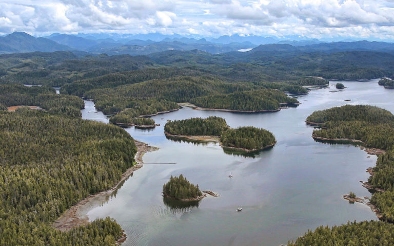
The GNN territory is in a remote area of the only accessible by boat or plane. In the past is has been relatively inaccessible to most, without incurring high costs to visit. With the increased availability of cheaper and better transportation, the general visits by the general public and industry have increased significantly in recent years. Monitoring these activities is paramount in the protection of the resources and history of the GNN peoples.
The guardian watchmen program is key to the protection of these resources. Lack of government funding to enforcement agencies leaves the territories without any monitoring and as such, the guardian watchmen fulfill this important role.
- Our guardian watchmen do frequent patrols in our homelands to ensure that rules and regulations are being followed and that visitors are being respectful of our territories.
- They work with various scientists participating in a variety of wildlife and fisheries research. To give you an example, they have done a bear project where they collected hair and monitored the bears through wildlife motion cameras. We want to learn all that we can about the delicate ecosystem in our territories as part of our responsibility to protect our territories and its resources for future generations.
- The guardians participate in all Archeological Assessment surveys or if a project needs monitoring when it is in a sensitive area.
- They also assist the fisheries crew when and where they can.
A geographic information system (GIS) is designed to gather, manage, store and analyze data. Rooted in the science of geography, GIS integrates many types of data. It analyzes spatial location and organizes layers of information into visualizations using maps and 3D scenes. With this unique capability, GIS reveals deeper insights into data, such as patterns, relationships, and situations- helping users make smarter decisions.
The GIS specialist oversees the collection and storage of data for the operations of the entire LRO. We manage spatial (mapping) data to inform the referral and consultation process within the Nation. Importantly, we also support the Nation’s data and information capacity system by running our own database that has spatial descriptions (like latitude and longitude coordinates), to complement our environmental and cultural information.
For example, our Coastal Guardian Watchmen are out in the field conducting patrols, where they record important observations and possible changes in the environment. Using the GIS we can compare their observations to any data and information we have from the past, such as culturally modified trees (CMTs) that are protected, or increased wildlife activity in a particular area. Our GIS Specialist reviews this information with LRO Manager(s) and may approach decision-makers in the community who are responsible for overseeing the stewardship of the territory’s resources. We can also use this information when we are approached about resource development in our territories, which will help determine whether there is an infringement on our rights and/or title.
The LRO is working to build capacity in our data and information systems, but we also support collecting and fostering community involvement in these activities. We support community-based research and are working with many partners both on and off-reserve to revitalize and improve community members access to language and culture, which also means reconnecting community members to the Homelands. It takes significant resources to make these activities happen, and community leadership, support, and participation are necessary to make community-based research successful. Our Elders especially provide critical guidance in these processes. We have used our grant resources for various activities, such as supporting field trips to the territory, providing honoraria for Elders participating in interviews while they speak our traditional language, funding youth to learn new skills, and activities that connect all community members in a positive and supportive way.
The GIS specialist oversees the collection and storage of data for the operations of the entire LRO. We manage spatial (mapping) data to inform the referral and consultation process within the Nation. Importantly, we also support the Nation’s data and information capacity system by running our own database that has spatial descriptions (like latitude and longitude coordinates), to complement our environmental and cultural information.
For example, our Coastal Guardian Watchmen are out in the field conducting patrols, where they record important observations and possible changes in the environment. Using the GIS we can compare their observations to any data and information we have from the past, such as culturally modified trees (CMTs) that are protected, or increased wildlife activity in a particular area. Our GIS Specialist reviews this information with LRO Manager(s) and may approach decision-makers in the community who are responsible for overseeing the stewardship of the territory’s resources. We can also use this information when we are approached about resource development in our territories, which will help determine whether there is an infringement on our rights and/or title.
We are constantly looking for ways to improve access to the Homelands for community members so that more time can be spent learning about the history of the Gwa’sala and ‘Nakwaxda’xw. We are continually building new infrastructure every year, including new boat docks and cabin improvements. Our fisheries crew and the Coastal Guardian Watchmen have a constant presence in the territory, and we aim to do the same for the general community. We encourage members of all ages to use the infrastructure out there, and to contact us if you have any questions around access and safety. Our treaty team also continues its work in reclaiming our homelands.